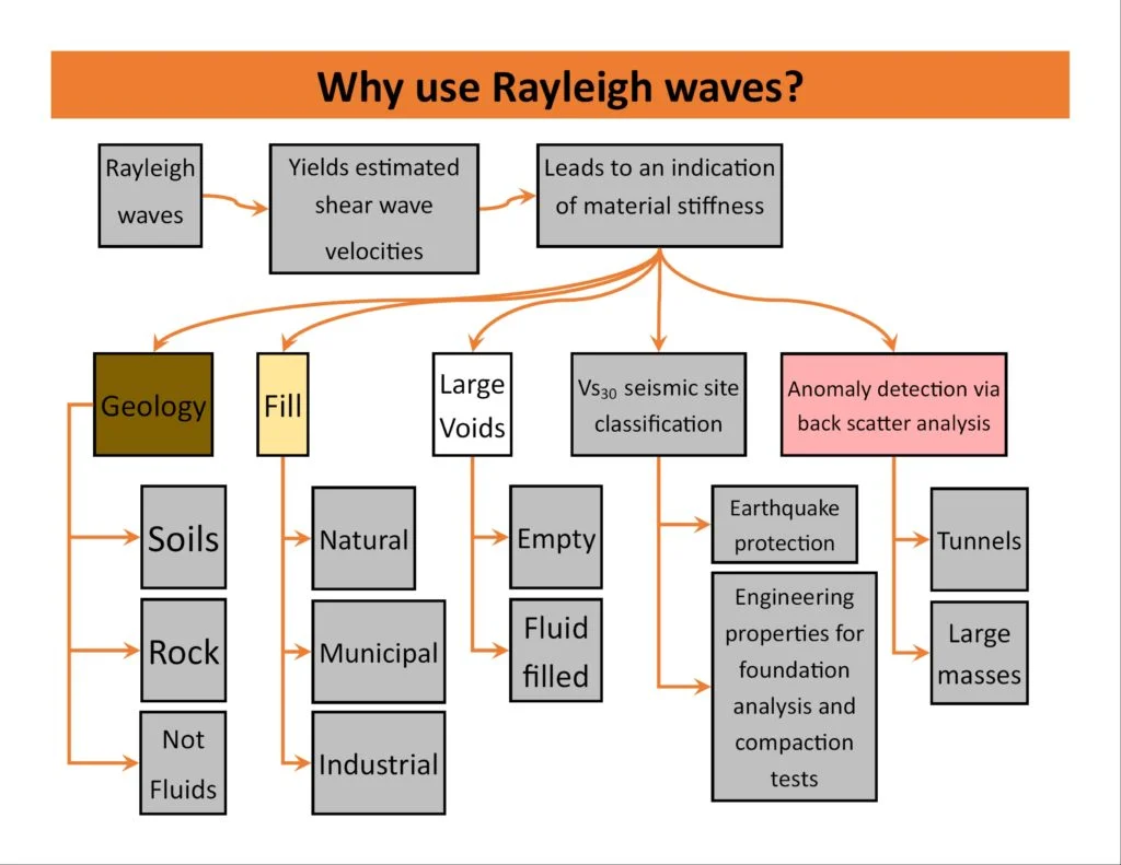
When a structural engineering firm proposed a three-storey residential development on the slopes of Lansdown overlooking central Bath, the initial desk study revealed a geological puzzle: the site straddled the boundary between the Great Oolite Limestone and the Fuller's Earth formation, two units with vastly different stiffness profiles. The project required a reliable seismic site classification under Eurocode 8, and conventional borehole methods risked missing the lateral heterogeneity. The solution involved a high-resolution MASW survey laid out along two orthogonal transects, which mapped the shear wave velocity structure to a depth of 30 metres and confirmed a Class B ground type across most of the footprint. This kind of investigation is now standard practice across Bath, where the UNESCO World Heritage setting often restricts intrusive drilling and developers need to demonstrate seismic compliance without compromising the historic fabric. The technique captures Rayleigh wave dispersion using an array of 24 geophones, then inverts the data to produce a 1D or 2D VS profile that feeds directly into the VS30 calculation required by BS EN 1998-1:2004.
MASW provides a continuous VS30 profile without a single borehole, making it the preferred method in Bath where drilling permits are constrained by heritage regulations.
Service characteristics in Bath
Critical ground factors in Bath
The contrast between two Bath neighbourhoods illustrates why VS30 cannot be assumed from a geological map alone. In the flat alluvial corridor of Lower Bristol Road, post-glacial silts and soft clays overlie the Lias Clay at depths of 8 to 12 metres, consistently yielding VS30 values in the 180–250 m/s range that place these sites in ground type C or even D—demanding higher seismic design coefficients. Meanwhile, barely 800 metres to the north, the terraced streets of Walcot rise onto the Bath Stone plateau, where the same MASW testing protocol returns VS30 values between 400 and 600 m/s, firmly within ground type B. Developers working on the River Avon floodplain who neglect site-specific shear wave velocity data risk underestimating the spectral acceleration by 30% or more, a margin that can cascade into foundation under-design and costly retrofit obligations. The Bath and North East Somerset Council planning department increasingly requests VS30 evidence as part of the geotechnical submission, particularly for buildings exceeding two storeys or those with irregular mass distribution.
Our services
Each MASW investigation in Bath is tailored to the specific geological unit and the project's seismic performance requirements. The following service configurations address the most common scenarios encountered across the city.
Standard VS30 Classification Survey
A single 24-geophone spread processed to deliver the VS30 value and Eurocode 8 ground type classification, suitable for residential projects on Bath's limestone plateaus where bedrock is expected within 10 metres. Includes a signed engineer's report with dispersion curves and inversion diagnostics.
2D Shear Wave Velocity Tomography
Multiple overlapping MASW spreads combined into a continuous cross-section, ideal for sites on the Bath valley floor where the alluvium–bedrock interface varies laterally. The 2D profile identifies soft zones that a single VS30 value would average out, critical for developments along the Avon corridor.
Combined MASW and HVSR Microtremor Survey
Pairs active-source MASW with passive horizontal-to-vertical spectral ratio (HVSR) recordings using a three-component seismometer. This dual approach extends the depth of investigation to 60–100 metres and captures the fundamental site period, recommended for taller structures in Bath city centre where deeper Lias Clay sequences influence the seismic response.
Quick answers
What does a MASW survey in Bath typically cost?
For a standard VS30 classification survey with a single spread in the Bath area, the fee ranges from £1,310 to £2,690, depending on site accessibility, the number of spreads required, and whether traffic management or pedestrian control is needed in central locations. The price includes mobilisation, data acquisition, processing, and a comprehensive report with the VS30 profile and Eurocode 8 ground type designation.
How deep can a MASW survey investigate in Bath's limestone geology?
With a 24-geophone array and a 46-metre spread length, the investigation depth typically reaches 25 to 30 metres, which is sufficient for the VS30 calculation required by BS EN 1998-1. For deeper targets, such as profiling the Lias Clay beneath the Bath Stone cap, we extend the spread or combine the active MASW with passive microtremor recordings, which can resolve shear wave velocities down to 60 metres or more.
Is MASW testing accepted by the Bath planning authority for seismic compliance?
Yes, MASW-derived VS30 profiles are accepted by Bath and North East Somerset Council as part of the geotechnical submission for planning applications, provided the survey follows the protocols of BS EN 1998-1:2004 and the data processing includes documented dispersion analysis and inversion with misfit statistics. We have submitted MASW reports for projects from the Riverside development to residential schemes in Bear Flat without query.
Can MASW be performed on small or congested sites in central Bath?
The method requires a linear geophone spread of at least 23 to 46 metres, which can be challenging in the narrow lanes of the Bath conservation area. For constrained sites we use a shorter array with closer geophone spacing and a higher-frequency source, trading some depth penetration for spatial feasibility. In extreme cases, a test pit investigation combined with downhole seismic measurements may offer a viable alternative.