The geology of Bath presents a distinctive challenge for any deep excavation, shaped by the interaction between Lower and Middle Lias Clay formations and a topography that rises over 200 metres from the Avon Valley floor. Unlike the London Basin, where stiff overconsolidated clays dominate, Bath's strata are heavily affected by the Camerton and Lansdown faults, creating zones of sheared material and variable weathering profiles that demand careful parametric selection. A contractor broke ground on a four-level basement near Camden Crescent only to encounter softened clay lenses at just six metres, which had not been identified in a preliminary desk study; the resulting instability required an urgent redesign of the shoring system. This scenario underlines why geotechnical design of deep excavations in this city must integrate a solid ground investigation with an understanding of local hydrogeological conditions and the restrictive planning framework imposed by the UNESCO World Heritage designation.
In Bath, the success of a deep excavation is measured not by the speed of the dig, but by the absence of a single hairline crack in a neighbouring Georgian façade.
Service characteristics in Bath
- Characterisation of the Lias Clay weathering grade (typically grades III to V in cut slopes) and its influence on undrained shear strength and stiffness degradation.
- Assessment of groundwater perched within the more permeable limestone bands of the Charmouth Mudstone Formation, a common source of basal instability in multi-level excavations near the river corridor.
- Integration of monitoring trigger values, aligned with CIRIA C760 guidance, to protect existing infrastructure such as the historic vaults that extend beneath many Georgian streets.
Critical ground factors in Bath
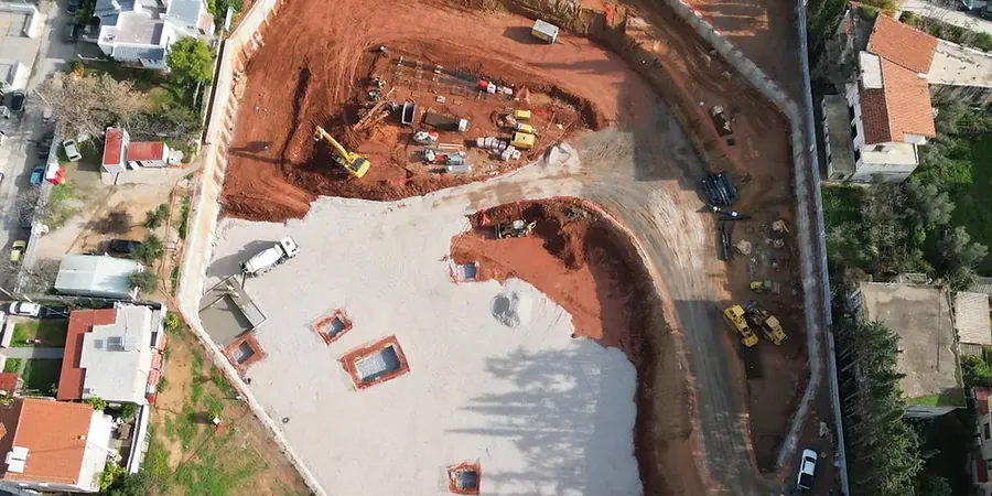
A six-storey residential development on a sloping site in the Bear Flat area began bulk excavation without a temporary works design that accounted for the pre-existing landslide topography mapped by the British Geological Survey. During a wet November, a rotational slip developed in the cut face, mobilising a mass of weathered clay that pushed the temporary sheet piles inward by nearly 400 millimetres and forced the evacuation of an adjacent terrace. The investigation afterwards confirmed that the original ground model had assumed a uniform weathered crust rather than the actual back-tilted slip surface left by a Pleistocene cambering event. This incident underscores the risk of relying on generic desk study interpretations when a site-specific ground investigation, including continuous sampling and inclinometer monitoring, is essential. In Bath, the proximity of the River Avon and its tributaries also introduces a high risk of basal heave in excavations that penetrate the more granular transition zones between the Lias Clay and the underlying Penarth Group beds, a condition that requires rigorous undrained stability checks using methods such as Bjerrum and Eide or finite element limit analysis.
Our services
The geotechnical design process for deep excavations in Bath moves through distinct phases, from initial feasibility through to detailed construction support, with each stage calibrated to the specific risk profile of the site and its surroundings.
Embedded Retaining Wall Design and Soil-Structure Interaction Analysis
We develop 2D and 3D finite element models using software such as PLAXIS or DIANA to simulate the sequential excavation and propping of retaining walls in the Lias Clay. The analysis captures the small-strain stiffness behaviour of the clay, the arching effects between soldier piles, and the time-dependent pore pressure response during construction. Outputs include bending moment and shear force envelopes for structural detailing, as well as settlement predictions used to negotiate party wall agreements with neighbouring owners.
Ground Movement Assessment and Heritage Impact Mitigation
This service focuses on the preparation of detailed ground movement assessments, using empirical methods such as Clough and O'Rourke profiles calibrated against local case histories, to demonstrate compliance with Bath and North East Somerset Council's planning conditions. We define instrumented monitoring schemes with automated total stations and in-place inclinometers, establishing amber and red alert thresholds that trigger contingency measures such as compensation grouting or additional propping levels before any damage can occur to protected structures.
Quick answers
What specific challenges do Bath's Lias Clay slopes add to deep excavation design?
The slopes exacerbate lateral stress relief during cutting and can reactivate ancient landslip surfaces that are common on the valley sides. Our design approach includes a detailed geomorphological review of the site, backed by inclinometer installations and residual strength testing on pre-cut slickensided samples, to ensure the temporary works remain stable under both drained and undrained conditions.
How is the risk of damage to Bath's Georgian listed buildings managed during an adjacent deep excavation?
Management starts with a Category 3 check according to CIRIA C760, which typically requires a full soil-structure interaction analysis rather than empirical settlement trough methods. We then work within the limiting tensile strain criteria for masonry structures, often specifying secant pile walls with a stiffness matching the surrounding ground, and installing real-time vibration and tilt monitoring on the most sensitive façades.
What is the typical cost range for a geotechnical design of a deep excavation in Bath?
For a complete design package covering ground interpretation, retaining wall analysis, and a ground movement assessment, fees generally range from £1.560 to £7.050, depending on the excavation depth, the complexity of the geological model, and the number of construction stages requiring simulation.
Which Eurocode provisions are most critical for deep excavations in this region?
The most critical provisions are found in BS EN 1997-1 Section 9 (Retaining structures) and Section 11 (Overall stability), applied through the UK National Annex. For the Lias Clay, Design Approach 1 Combination 2 often governs the structural design of the wall, while the serviceability limit state checks against BS 8002 ensure that ground movements remain compatible with the stiffness of the historic building stock.
Can the design be adapted if unexpected ground conditions are found during the dig?
Absolutely. Our designs are prepared with an observational method framework in mind, as recommended by CIRIA R185. We pre-define a range of likely geological variations and establish contingency designs for each, so that if a fault zone or a perched water pocket is encountered, the site team can immediately implement a revised propping sequence or dewatering strategy without stopping work for a full redesign.