Bath’s urban fabric is inseparable from its geology: the honey-coloured Bath Stone sits above a complex sequence of Lias clays and river terrace deposits that have challenged engineers since the Georgian expansion. When the city’s thermal springs first drew Roman builders, seismic resilience was not part of the brief, but modern conservation-led development along the Avon valley requires a rigorous understanding of how the ground will behave during a tremor. Our work in seismic microzonation has mapped significant impedance contrasts where stiff limestone overlies softer mudstone, producing amplification patterns that generic UK hazard maps simply cannot capture. We combine borehole logging with active MASW surveys to define Vs profiles at outcrop scale, feeding directly into site classification under BS EN 1998-1:2004 for projects within the World Heritage boundary.
Two sites in Bath separated by 300 metres can exhibit ground type D and ground type C under Eurocode 8, a difference that changes design spectral accelerations by nearly 40 percent.
Service characteristics in Bath
Critical ground factors in Bath
The Lias Clay that underpins much of Bath’s northern slopes presents a specific seismic risk that goes beyond simple amplification: its high plasticity index, typically between 25 and 40 percent, makes it susceptible to cyclic softening during prolonged shaking. This is not a theoretical concern. The Avon Valley fault system, while considered low-seismicity, has produced events up to magnitude 4.5 in the Bristol Channel basin, and the resulting ground motion at the clay-limestone interface can degrade stiffness rapidly. For structures retaining the historic terraces along Lansdown Road or new builds on Beechen Cliff, ignoring site-specific response analysis invites differential settlement and façade cracking that would be both costly and diplomatically sensitive in a conservation context. Our microzonation reports include degradation curves calibrated to local samples tested under cyclic triaxial conditions, giving structural engineers the modulus reduction data they need for performance-based design.
Our services
We deliver three integrated components within each microzonation study, aligned to the specific conservation and engineering constraints of Bath.
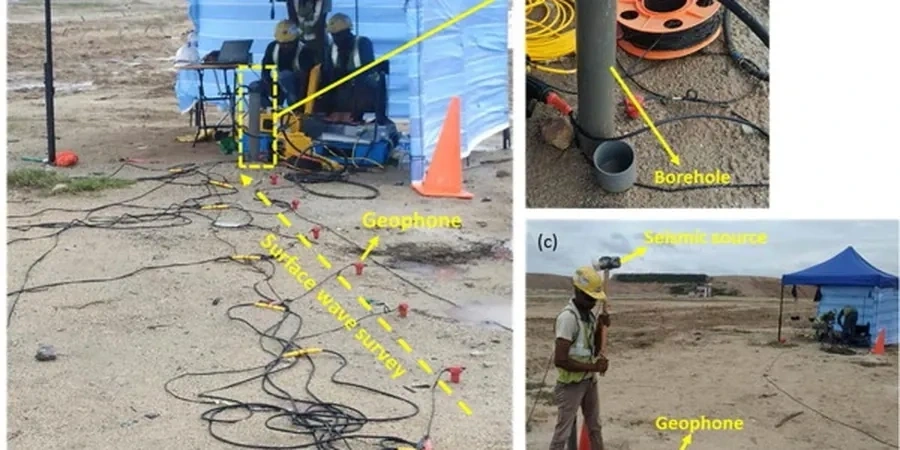
Geophysical field surveys
MASW, downhole and HVSR acquisition along transects calibrated to BGS mapping, processed to extract Vs profiles and Vs30 grids.
Site response analysis
1D and 2D equivalent-linear modelling using DEEPSOIL or similar, generating design spectra, amplification maps and Arias intensity distributions.
Liquefaction and cyclic assessment
Evaluation of granular river terrace deposits using SPT-based and Vs-based triggering procedures, with post-liquefaction settlement estimates.
Quick answers
What does a seismic microzonation study cost for a typical Bath development site?
For a site-specific study covering geophysical acquisition, laboratory testing and 1D/2D modelling, budgets in the Bath area generally fall between £3,560 and £14,650. The range reflects the size of the parcel, the number of geophysical lines required and whether cyclic laboratory testing is needed on local Lias Clay samples. We provide a fixed-price proposal once we review the site location and the BGS superficial geology mapping.
Is seismic microzonation mandatory for projects in Bath?
Under UK Building Regulations and BS EN 1998-1:2004, a seismic hazard assessment is required for structures of consequence class CC2 and above, particularly when the site lies on ground types D or E. In Bath, the combination of heritage listing and variable ground conditions means that planning authorities and conservation officers frequently request a site-specific microzonation report even for mid-rise residential schemes, especially on sloping sites near the Avon valley margins.
How do you handle access constraints in Bath's historic centre?
Bath's narrow Georgian streets and World Heritage status mean we often cannot deploy large vibrator trucks. We use portable MASW arrays with wireless geophones, lightweight impact sources and single-station HVSR measurements that can be set up in a standard parking bay. All equipment is non-invasive and generates no vibration that could affect adjacent listed structures: an absolute requirement when working within the conservation area.
What deliverables do we receive at the end of the study?
You receive a UKAS-accredited factual report containing Vs profiles, Vs30 contour maps, ground type classification per Eurocode 8, design response spectra for each zone, amplification factor maps and a liquefaction screening summary. We also provide the electronic geophysical data in SEG-2 format and the site response model input files so your structural engineer can verify or extend the analysis independently.