The geotechnical contrast between Bath's upper slopes and the river corridor is striking, and it dictates every stability assessment we carry out. Up on the flat-topped hills around Lansdown and Claverton Down, the Great Oolite limestone forms a resistant caprock that can mask weaker layers beneath, while down in the Avon valley the river has cut through into the Lias clays that are notorious for their low shear strength. A structure on Camden Road faces a completely different set of stability challenges than one down by the Widcombe basin, not just because of the gradient but because the underlying stratigraphy changes so rapidly across the city. Before any earthworks begin, we typically combine a slope stability analysis with targeted test pits to log the clay-limestone interface, and where foundation loads are concentrated near the crest we recommend SPT drilling to quantify the strength profile that will govern the factor of safety.
In Bath's Lias clay slopes, the residual friction angle can drop to just 12 degrees after movement, making back-analysis of existing failures essential for reliable design.
Service characteristics in Bath
Live process video
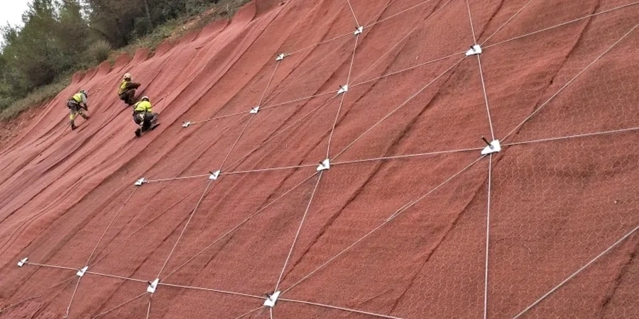
Critical ground factors in Bath
The Charmouth Mudstone that underlies much of lower Bath has a well-documented history of landsliding, most notably across the Beechen Cliff and Holloway areas where the clay weathers rapidly to a softened, slickensided fabric with dramatically reduced shear strength. When we investigate a site on these slopes, we are looking for evidence of previous movement because remoulded clay along a pre-existing slip surface can have a residual friction angle as low as 8 to 12 degrees, meaning a slope that appears stable in summer can become marginal after sustained rainfall raises pore-water pressures. The risk is compounded by Bath's dense urban fabric: many slopes support terraced housing, retaining walls and buried services, and a failure that starts as a shallow rotational slip can propagate uphill and affect multiple properties. Our stability assessments in these areas always include a sensitivity analysis that varies the groundwater level parametrically, because the difference between a dry winter and the record rainfall of 2013-14 can be the difference between a factor of safety of 1.4 and one that drops below unity. Where analysis confirms an unacceptable risk, we specify drainage measures to lower the phreatic surface, often combined with soil nailing or ground anchors installed through the weathered zone into competent limestone.
Our services
Our slope stability work in Bath draws on a complete suite of in-house investigation and analysis capabilities, allowing us to move from initial reconnaissance through to detailed design without the delays of subcontracting specialist testing. The two service packages below represent the most common scopes we deliver for hillside sites across the city.
Stability assessment for existing development
When homeowners or developers need to demonstrate that a slope adjacent to an existing structure is stable, we carry out a desk study, walkover survey and targeted ground investigation to build a geotechnical model, then perform limit equilibrium analysis to calculate the factor of safety under both drained and undrained conditions. The output is a factual and interpretative report suitable for planning submission or building control approval, with clear recommendations for any remedial measures required.
Design-stage analysis for new earthworks
For proposed cuttings, embankments or terraced developments on Bath's hillsides, we provide a full design package that starts with pre-construction stability modelling to optimise the slope angle and benching geometry, and continues through construction with validation testing of fill compaction and pore-pressure monitoring. Where the analysis indicates that an unreinforced slope cannot achieve the required factor of safety, we design soil nailing, anchored mesh or groundwater control systems integrated with the overall earthworks specification.
Quick answers
What triggers a slope stability analysis to be required in Bath?
Typically, a slope stability assessment is required when a proposed development is within a certain distance of a slope crest or toe, or when the slope exceeds a threshold gradient — often around 1 in 3 for clay soils. In Bath, the planning authority will frequently request a stability report for sites on the valley sides, particularly where the Charmouth Mudstone Formation is mapped. The requirement also arises when building near retaining walls that support public highways, or when extending existing structures on hillside plots where historic movement may have occurred. The trigger is usually a planning condition, but prudent developers commission the assessment early to avoid redesign costs later.
How long does a slope stability investigation and analysis take?
A typical programme for a site in Bath runs between six and ten weeks from instruction to final report. The first two weeks cover the desk study and walkover survey, followed by one to two weeks for the ground investigation fieldwork — drilling boreholes, excavating trial pits, installing piezometers. Laboratory testing of soil samples, including triaxial and ring shear tests to determine strength parameters, takes around four weeks. The stability modelling and report writing then occupy the final two weeks. Sites with complex geometry or where long-term groundwater monitoring is needed will extend the programme, and we always advise clients to factor in at least one full winter season of piezometer readings if pore-water pressure is likely to govern the design.
What is the typical cost range for a slope stability analysis in Bath?
For a single slope assessment on a residential site in Bath, the cost typically falls between £1,020 and £2,960 depending on the scope of ground investigation required. A straightforward desk study with walkover and basic stability modelling sits at the lower end, while a full investigation with boreholes, laboratory testing, piezometer installation and detailed limit equilibrium analysis reaches the upper end. Larger commercial sites or slopes affecting multiple properties will exceed this range, and we provide a fixed-fee quotation after an initial site visit so there are no surprises.
Can you assess slopes that have already failed?
Yes, and in Bath this forms a significant part of our caseload. Assessing an existing landslide requires a slightly different approach — we carry out a back-analysis of the failure to determine the shear strength that was operating at the time of collapse, which gives us a calibrated set of parameters for designing remedial works. This involves surveying the slip surface geometry, recovering samples from the shear zone, and running the stability model in reverse to solve for the friction angle that would produce a factor of safety of 1.0 under the groundwater conditions at the time of failure. The back-analysed strength is then used to design drainage, regrading or reinforcement that will restore an adequate margin of safety.
How do you account for Bath's hot springs and groundwater in stability analysis?
Bath's thermal springs are a unique hydrogeological feature, but they rise from the Carboniferous Limestone at depth and do not generally interact with the shallow slope stability regime in the Jurassic strata. However, groundwater more broadly is often the critical factor in Bath's hillside stability. We install standpipe piezometers at multiple depths to measure pore-water pressure profiles, and where perched water tables develop above the clay layers — a common scenario on the upper slopes where limestone overlies mudstone — we model the seepage regime explicitly. The analysis accounts for both steady-state groundwater flow and the transient response to extreme rainfall events, because it is the rapid rise in pore pressure during prolonged wet weather that triggers most failures in the Lias clays.